
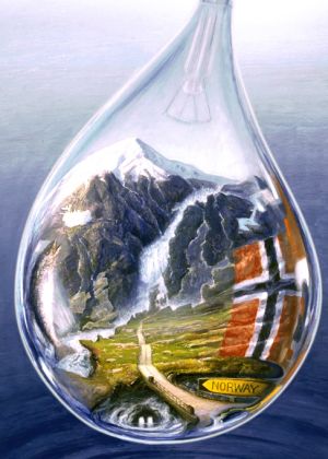
strange maps’ find The Norwegian Drop was “a poster proposal for Norway’s pavilion at the World Exhibition in Seville (Spain) in 1992.” As the post explains, “[The] painting is aimed at visualizing how [hydroelectric power] is entirely renewable and is a result of Norway’s distinct geography.” Definitely check out the full-size version and see if you can spot these geographic features:
- Norway is a foaming mass of water gushing down a rocky mountainside that to the right looks like the rest of Scandinavia.
- A nice touch: Iceland is formed by a… spot of ice on the side of the mountain towering over the landscape.
- Rivulets of water form the boundaries of Finland and Sweden, Russia’s Kola peninsula is defined by the stagnant pond next to it.
- The ‘head’ of Norway at its southern end is a waterfall, perpetually showering Denmark’s Jutland peninsula with crystal clear Norwegian water.
- That water flows on to etch the edges of Europe out of its rocky landscape – clearly a reference to what the northern desolation of Norway must look like.
- A road winding down through northern Germany, past the Benelux countries and via France leads to where Italy should be. Instead, a road sign invites us to take the other direction, up towards Norway.
- To the left, a salmon and the British Isles are floating quite mysteriously above the water – perhaps all three of them have just leapt up out of the mountain stream.